York Central Transport and Access – Professor Tony May

Post its of key ideas noted at the workshop with Tony May.

Wednesday 11th April, 7:00pm – 9:00pm
National Railway Museum Gallery

York resident Dr Tony May specialises in urban transport and has provided advice in the UK, Europe and internationally. He is the transport specialist on York Civic Trust’s Planning Committee. This event included an illustrated talk bringing in examples from the Vauban project in Freiburg to examine how sustainable transport can genuinely form the heart of new development, shaping it and making it a pleasant and more affordable place to live and work. We discussed the current emerging masterplan, how closely this reflects the priorities set out in York’s Local Transport Plan, and how it might be further developed to make both the new development and surrounding existing communities more sustainable.

Presentation
Tony May opened by giving a talk – you can read his presentation here.

Questions
There were then a series of questions from the audience.

Q: Vauban – how does the parking work?
Residents can choose to have a car, but if they have one they have to pay for a space in one of two multi-storey car parks. They pay the actual cost of provision (land & construction) which is between €18,500-€22,500 plus a monthly service charge. Car ownership is 160 cars per 1000 residents, compared with 299 elsewhere in Freiburg. There is evidence of a trend towards car ownership being less important for young people, they are interested in alternatives like car clubs and car sharing. In inner city areas, high quality public transport can encourage people to leave their cars.

Q: What about deliveries in Vauban? What if you were having a washing machine delivered?
In central London a landowner I am working with managed to reduce deliveries by 50-70% by having a central pick up point. It wouldn’t work for washing machines but then we don’t get washing machines delivered every day.

Q: Leeman Road traffic, where will it go?
There is interesting research which says that if you reduce roads then some of those journeys just don’t happen – or they happen in different ways. But knowing what people are doing instead is difficult to research. You can increase the capacity of the road network through some tinkering in order to ease congestion, as we’ve shown with the Fishergate Gyratory.

Q: I want to be able to drive down Leeman Road, not to get into the centre of York but to get across York.

Q: In terms of parking, there would need to be no on street parking and restricted parking in all neighbouring areas or there is the potential for displacement parking.
If you manage parking then you have to cover an area that is much larger to avoid displacement.

Q: Station plans: if you have a new multi-storey and buses and taxis coming to the back of the station, then all the traffic would still be coming through Marble Arch.
At our meeting with Arup it seems they were planning for a 500-place multi-storey car park, to be shared between NRM and Network Rail. There is also the potential for a multi-storey on the Railway Institute site.

Q: Does it make sense to use existing rails for Very Light Rail?
There has been talk about a Harrogate / Scarborough line (where trains only run once per hour) use of existing rails. But on other lines the frequency of trains is much greater. But Very Light Rail needs significance investment. Where are people coming from to the station, I’ve not seen those figures.

Q: I live 3 miles from York Station and go there regularly for work, but the Park and Ride is just too slow. We need tram or something similar to get people like me out of my car.

Q: HS2 – how does that fit into the future economic development of York?
There is a danger by connection big and dynamic A-type cities (like Manchester and Newcastle) that B-type cities like York suffer. If York is not active in pursuing economic development then HS2 or any increased connectivity will be to the detriment of York.

Q: Why are they doing what they are doing with Queen Street Bridge?
The Council got Yorkshire Transport Infrastructure funding to do a number of things – including the York Central Access route – and the Queen’s Street Bridge was one of them. The money needs to be spent by 2021.

Q: Can we bring trams to York?
Trams in the UK have a chequered history. They have tended to be overdesigned, like in Manchester, and are therefore very expensive. They tend to be privately operated. And they are expensive to get up and running, Leeds has been trying for 25 years. Very Light Rail is being looked at in Warwick University to be tried out in Coventry, this could be lower cost. This would require a conversation with Network Rail. This is something to be discussed in York’s Transport Plan.

Focused small group discussion
We then broke into groups to look at different questions:

Walking and Cycling: What should the networks look like?
• Better walking and cycling connection from Wilton Rise – to then connect into the new Scarborough Railway Bridge was seen as a very good thing that opened up entirely new off road routes.
• Closely Leeman Road was questioned – it is very busy and how can we stop the other new road being through route and 24h access for pedestrians was seen as essential. Rijksmuseum was mentioned.
• Prompted by this we looked at the options for Marble Arch (which ‘is an embarrassment’). It was noted that any traffic that did come through would be driving through the new square.

Public Transport: What should the network look like?
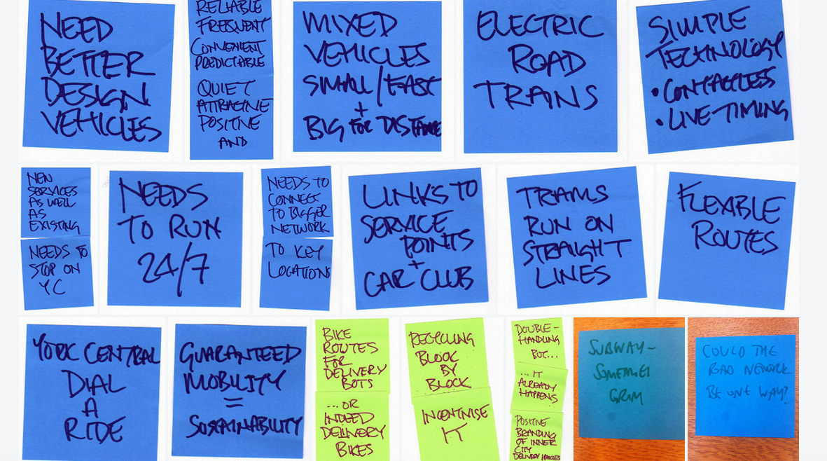
• The network needs new services in addition to re-routing of existing ones. They need to actually stop in York Central, and need to operate as close to 24/7 as possible.
• The network needs to connect both with the broader York and regional network (people want to travel from York Central elsewhere in York, not just to the centre of the city and they don’t want complex/slow connections) and with destinations within York Central such as service points, car club locations etc.
• We need better-designed vehicles so they are seen positively, but they also need all the basics so need to be convenient, predictable, quiet, attractive. Also need to make use of current good technology like contactless and live timing displays.
• We need mixed vehicles to cope with longer/shorter distances, so small for local and bigger for “trunk” routes. Small ones could be “driverless pods” or could be like the NRM road train but electric.
• Trams tend to work well on straight lines, buses cope better with wiggly networks.
• “Sustainability” has to include guaranteed mobility for those with disabilities. Can we have a York Central Dial-a-Ride?

Provision for parking:
• A key driver to the discussion was ‘tomorrow’s solutions, not today’s’. So let’s know assume everyone wants a car. Where will autonomous vehicles park?
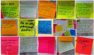
• A lot of discussion about the benefit of meeting spaces near to the station (add in post its). It was noted Clifton Moor office space – with a lot of parking attached – was being turned into office space.
• A model like Vauban – with parking on the edge – was broadly supported. Though the group was a bit worried about how Tesco deliveries would be taken in (Tony said, carry it down the street!).

Provision for servicing
• Dedicated cycle routes give options for use as dedicated delivery routes – either with “delivery bots” or simply cycle couriers.
• Trans-shipment involves “double handling” of goods but this is part of the process anyway – we just don’t see it (look at online tracking of any parcel to see how many separate journeys are involved). There are positive branding opportunities in this – M&S can offset extra costs of handling for local transhipment by ensuring the delivery vehicles have “M&S supports local zero-carbon deliveries” all down the side.
• Recycling – needs consideration as part of the design process (keep it close to homes / work) and also management process (how can it be incentivised, like at student halls).

Connecting York Central and Holgate

Friday 13th April
One of the key issues that has emerged from conversations within the Festival of York Central has been connections between the new development and existing surrounding communities. It’s recognised that the existing footbridge across the goods line which connects Cinder Path and Wilton Rise is not ideal, and the masterplanning team are exploring options to improve this connection. These include replacing the existing bridge with something better in the same location, providing an improved connecting route, replacing the bridge in a new location, or doing nothing. The aspiration would be for the new bridge to be more usable for cyclists, for wheelchair users and for those with prams and push chairs. We leafleted all properties in the area and then in collaboration with the friends of Holgate Community Garden, walked the routes to take a look at the options.

Throughout the conversations there were some “bigger picture” questions raised:

‘What will be the increase in volume of walking and cycling? Who will be using the routes when the development is completed? We need to have all the information in order to make a decision’.

As well as some statements of principle discussed:

‘York Central shouldn’t be to the detriment of the people who already live here’.

We have then organised the responses underneath the four options proposed in the York Central masterplan.

Option 1 is the red line on the map.

Option 1: Wilton Rise, replace the existing bridge.

‘Could the bridge widen out from the south as it crosses the railway?’
‘It’s got busier, the bridge can’t cope and it’s affecting residents’
‘Lots more bikes and lots more pedestrians – I’m not sure the surroundings of the bridge can sustain that, screeching bikes, noisy roller suitcases, high heels. The streets are narrow’.
‘I didn’t envisage when I bought the house that it would be a thoroughfare into town’.

As you can see from the information, one of the issues raised for any route was whether it goes through the unadopted Wilton Rise. Being unadopted means the residents and not the council are responsible for maintaining the street. Currently there are a number of potholes and cracked pavements.

It also restricts the possibilities for restricting/controlling parking. ‘We will soon have residents parking (Respark) in the terraced streets near the bridge but not on Wilton Rise as that is an unadopted road’.

Option 2 is the route indicated in yellow.

Option 2: Wilton Rise, new line for the bridge.

‘It is a bit bonkers’
‘This location for a bridge is something people didn’t sign up for when they moved here’
‘It depends on what would be on the other side – would it be bars?’
‘So the new empty offices will go there, will they?’
‘How high will the buildings be on the York Central side?’
‘This is a great view of the Minster – but not an “acknowledged” view’
‘This option doesn’t solve the Wilton Rise issue’.

The question remains in terms of volume of cyclists and pedestrians.

Option 3 is indicated in blue and shows a new route up Chancery Rise.

Option 3: a new path coming up Chancery Rise leading to a new bridge
This Option 3 follows the line of one the proposed routes for a new access road (the final access route chosen was the one from Water End via Millennium Green).

In principle there was an interest in the positive aspects of more people using the Holgate Community Garden and good use of any cycle path:

‘This is an “asset of community value” garden – we want people to use the garden’.
‘The more people that use any new cycle path – and the garden as well – less chance for anti-social behaviour’.
‘We want the garden to be put on the map and be better used’.

But there were some specific concerns and some specific requirements that would need to be taken into account:

Where exactly will the route go:
‘There is a massive height difference so they’d have to start ramping it very early’.
‘The worry is they will start shaving bits off the garden and play area. It’s been a long fight to protect this’.
‘There is perhaps the piece of waste land on the other side of the fence (and the basket ball court)’.
‘The bike path would not be overlooked here (to the rear of and below the Wilton Rise gardens– so it would need to be very well lit at night’.
‘We wouldn’t want to lose the trees. The trees are useful for shading and reducing noise, we’d want to keep the trees.’

Any option would need to take into account and build on the Holgate Community Gardens specialness:
‘At the moment this works well as an enclosed space where children can run around without them wandering off’.
‘The basketball court is used by groups including by the school for PE, so that would need to be kept’.
‘The residents of the area, would want ‘to get onto the cycling path at the end of the garden’ – but want the point above noted in terms of the benefits of enclosure.

Option 4 didn’t seem overly different or worthy of specific discussion as it was effectively the same as Option 1; and proceeding as if people wouldn’t use Wilton Rise if that was their shortest route didn’t seem useful.

Other options:
‘Is there another option which is further along (beyond the Holgate Works, where the business park is). The benefit would be not having to come up (the line of the railway) to go back down again.’ This had also been mentioned previously as a good link between the development and Acomb’s shops/businesses.

Notes on cycle routes:
The rejection of Option 4 was in part as a result of feelings about marked cycle routes. The streets have little vehicular traffic but a lot of parking, meaning the pragmatic safest route is often straight down the middle of the road, in order to give best sightlines for any emerging traffic and to keep clear of opening car doors. There would be little point in marking a cycle route on either side of any of the roads as it would be ignored.

Final thoughts:
• Adopting Wilton Rise: It seemed as though the recent adoption offer to Wilton Rise had been unattractive for the residents as there was an initial payment to cover assessment which would be followed by an unknown amount to bring the road up to standard before adoption. Could this offer be revisited as part of these masterplan discussions?
• Is connectivity always good? There has been an assumption that connectivity is good but there were voices of concern about great connectivity to the new community that York Central would bring. A question raised is how to recognise that communities need some kind of boundary and yet also create routes through…how do we design for both?

Open Briefing Document – Movement

Week 4 of the Festival of York Central was focused on ‘movement’, asking how people wanted to get to, across and around York Central. We’ve gathered information through social media and through a series of events:-

  1. Beyond Flying Cars – sustainable transport on York Central – joint York Environment Forum / York Bus Forum open event
  2. Getting Out More – family drop in workshops leading to production of a zine
  3. York Central Transport & Access with Professor Tony May
  4. Connecting York Central & Holgate – walk with local residents re proposed southern pedestrian/cycle access routes
  5. Out and About workshop sessions with pupils of St.Barnabas and Poppleton Road schools
  6. What Makes a Good Cycle Route – guided ride and workshop with York Cycle Campaign
  7. Pulling together the Week’s Conversations – public workshop (with The Life Sized City film show)

We have also drawn upon movement-related discussions during previous weeks – for example on issues of legibility in shared space (from our Open Spaces discussions) and the role of transport in urban development (from the David Rudlin workshops). In addition, tagging of comments from previous events has allowed us to put responses from the week’s events in a broader context of overall comment, questions, etc.

Here are the main issues and comments:-

Some key principles:

York Central cannot be seen in isolation. One of the recurring themes of discussions on movement was integration – transport modes and routes need to connect to make them useful. A truly high quality transport network on York Central needs to integrate with a truly high quality transport network across the city. So:-

  • People felt that York Central should set an example of innovative, forward-thinking sustainable transport and…
  • York Central should be an opportunity to leverage change across the city and bring forward broader innovation – for example new networks (Very Light Rail, continuing through the city and onwards to Heslington / Elvington) and processes (freight trans-shipment for local deliveries, with small electric vehicles / cycle couriers).
  • We should design for behaviour patterns that we want in future rather than just to work with current patterns (for example prioritising active travel).
  • Prof Tony May set out the hierarchy of priorities within the draft Local Plan and stated clearly that design of movement infrastructure within York Central should reflect this, with clear and convenient walking/cycling routes occupying space best suited to them, and vehicular routes elsewhere. This was widely supported.
  • There should be better separation between vehicular routes and cycling routes – these should be truly segregated (not immediately adjacent) and walking/cycling routes should always have priority.

The need was identified for good-quality information to steer future decision-making. For example:-

  • What will changes in overall age of population mean for transport demand? Will there be more people with mobility issues? More mobility scooters?
  • Can we obtain information about what journeys people want to make (not simply traffic counts on roads – information about “why”) so we can consider and design for end-to-end journeys?
  • What is the basis for decision-making on car use/ownership? Is this simply the status quo (“most people have cars, so we design residential areas for cars since moving away from this would result in resistance”) or is this on the basis of alternative possibilities (“there must be lots of people for whom a car-free neighbourhood this close to the centre would command higher house prices”).

Reducing movement by reducing zoning

Can we reduce the need for people to move around by the way we plan the development?

“We thought the future would be working from home and having meetings via Skype; do we no longer believe that we’ll all be working from home?” “It’s not become an either/or, people are not using it as a replacement”.

There seem to be movement implications from this as follows:-

  • Working from home will still require movement but this can be largely walking/cycling
  • Small/medium businesses (for example creative industries) often involve “clustering” where good local connections (again walking/cycling) are important.

Public transport and the rest of York: Ease of use and Integration

  • Seamless connections with a wider network are needed to allow necessary longer journeys – simply getting to the city centre is inadequate if onward connections aren’t easy and fast.
  • This needs to consider both the radial routes and movement between them – York is poor for this.
  • Ease of use is essential – contactless payments on all transport modes, and operating times / pricing models which suit users rather than just operators (current Park & Ride arrangements were frequently criticised).
  • All of which points to a requirement for some over-arching strategy and an appropriate body to administer it, an equivalent to Transport for London – Transport for York – was mooted.

Pedestrian and cycle movement

Key points were that:-

Cars on York Central: Low car development and no through traffic

A crucial choice is whether there is through traffic across York Central. One comment was “If you allow through traffic, this is where all ideas of being radical evaporate”.

Many people noted that there seemed to be an assumption that “restricting car use/ownership” was seen as problematic and would decrease the appeal of living/working on York Central, but that this was open to challenge. There were many suggestions that a car-free neighbourhood would be very popular and would command premium prices. “People will have a choice – no-one is being forced to live here”.

Prof Tony May set out a proposal for York Central based upon the Freiburg Vauban development – allowing car access but with centralised parking, creating Play Streets and safe walking/cycling routes. It was noted that this would require consideration (for example Respark areas to prevent “overspill”) beyond the site. This side-steps the “ban cars” challenge by allowing ownership but passing on real costs and making alternative modes more attractive.

Prof May’s ideas envisaged centralised parking at the north-west end of the site, close to the access from Water End. Bringing cars deep onto the site to multi-storey car parking adjacent to the station was felt to be a backwards step, which would greatly reduce safety within the development. Parking for service use (tradespeople etc) was discussed and it was felt bookable spaces could be provided. Local deliveries could be to service points, combined with public transport stops or parking areas.

Marble Arch / Leeman Road tunnel: How to avoid traffic cutting up the New Square

People stated that the main access to the site (and NRM) from the city needed to reflect the City’s transport priorities – it should be a good route for those walking / cycling etc. Its poor visual appeal was noted and the question was asked “what would it take to turn it into the gateway to a major museum?”

The impact of through traffic on the new square was frequently mentioned. Both two-way through traffic and light-controlled alternate traffic (Option 2 on the Marble Arch board) were thought likely to lead to queuing traffic in what has been described as a pedestrian civic space, which should be avoided. Traffic was furthermore seen as a potential barrier between the NRM and the station / city centre.

National Railway Museum through access: A creative opportunity to celebrate movement

There was almost complete opposition to the closure of Leeman Road to pedestrians/cyclists outside NRM opening hours. It was noted that modelling suggests it would take people on foot 1.5 to 3.15 minutes longer when the museum was closed. There were comments like ‘it’s not about how much longer it will take’, ‘it’s the psychological factor of feeling cut off and that the museum is blocking you’.

More positively, there were comments like “I don’t think it’s about the time saved or not, it’s about the experience and qualities of being able to walk and cycle through the museum”. There were repeated requests for a more creative solution which celebrated movement (“it’s bizarre that a museum of movement would cut off movement”) and the Rijksmuseum in Amsterdam was cited as a good example of what could be possible, with new opportunities for the public to see exhibits while maintaining out-of-hours security. Creative possibilities were identified around rotating doors or a turntable in the link building – “like the Gateshead Millennium bridge – people would come to watch it open!” and “the shadowy trains in the closed museum are far more atmospheric than when it’s open”.

Connections to existing communities

There has been an assumption that York Central should connect to surrounding communities but this was noted to have challenges:-

  • The simple fact that people who are used to being disconnected from public movement may be suspicious of change
  • Issues to do with alcohol and antisocial behaviour – new bars in York central leading to hen parties making noisy progress through surrounding communities
  • Places which offer security (for example Holgate Community Garden) becoming open and routes for (pedestrian/cycle) through-traffic.

There was a broad point made that the development needs to provide positive benefits for existing nearby residents and needs to clearly spell these out. “You compromise. Part of this is “I’m not going to get that bit that I really want but I’m going to get that other bit instead”. There has to be a quid pro quo”. This applies to movement as well as other facilities.

Discussion of the proposed southern connection is covered in a separate document.