Friday 13th April
One of the key issues that has emerged from conversations within the Festival of York Central has been connections between the new development and existing surrounding communities. It’s recognised that the existing footbridge across the goods line which connects Cinder Path and Wilton Rise is not ideal, and the masterplanning team are exploring options to improve this connection. These include replacing the existing bridge with something better in the same location, providing an improved connecting route, replacing the bridge in a new location, or doing nothing. The aspiration would be for the new bridge to be more usable for cyclists, for wheelchair users and for those with prams and push chairs. We leafleted all properties in the area and then in collaboration with the friends of Holgate Community Garden, walked the routes to take a look at the options.
Throughout the conversations there were some “bigger picture” questions raised:
‘What will be the increase in volume of walking and cycling? Who will be using the routes when the development is completed? We need to have all the information in order to make a decision’.
As well as some statements of principle discussed:
‘York Central shouldn’t be to the detriment of the people who already live here’.
We have then organised the responses underneath the four options proposed in the York Central masterplan.
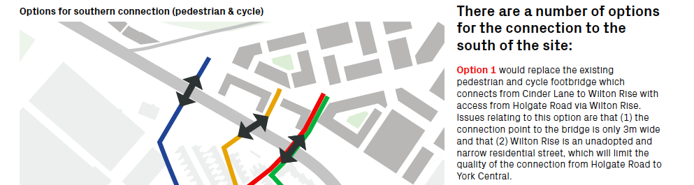
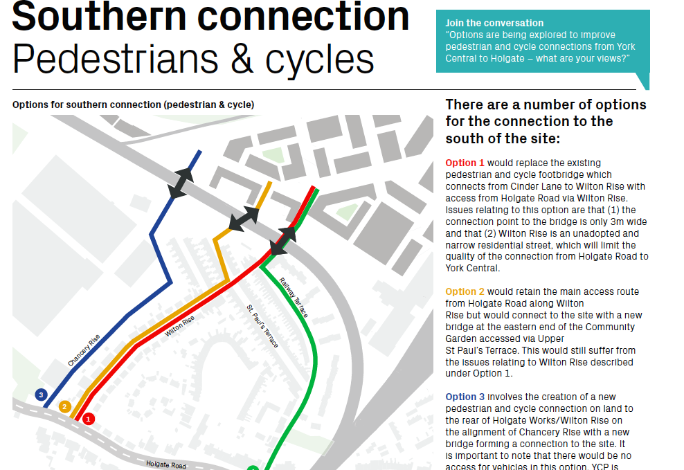
Option 1: Wilton Rise, replace the existing bridge.
‘Could the bridge widen out from the south as it crosses the railway?’
‘It’s got busier, the bridge can’t cope and it’s affecting residents’
‘Lots more bikes and lots more pedestrians – I’m not sure the surroundings of the bridge can sustain that, screeching bikes, noisy roller suitcases, high heels. The streets are narrow’.
‘I didn’t envisage when I bought the house that it would be a thoroughfare into town’.
As you can see from the information, one of the issues raised for any route was whether it goes through the unadopted Wilton Rise. Being unadopted means the residents and not the council are responsible for maintaining the street. Currently there are a number of potholes and cracked pavements.
It also restricts the possibilities for restricting/controlling parking. ‘We will soon have residents parking (Respark) in the terraced streets near the bridge but not on Wilton Rise as that is an unadopted road’.
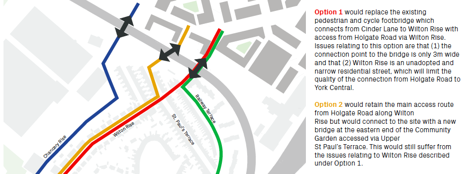
Option 2: Wilton Rise, new line for the bridge.
‘It is a bit bonkers’
‘This location for a bridge is something people didn’t sign up for when they moved here’
‘It depends on what would be on the other side – would it be bars?’
‘So the new empty offices will go there, will they?’
‘How high will the buildings be on the York Central side?’
‘This is a great view of the Minster – but not an “acknowledged” view’
‘This option doesn’t solve the Wilton Rise issue’.
The question remains in terms of volume of cyclists and pedestrians.
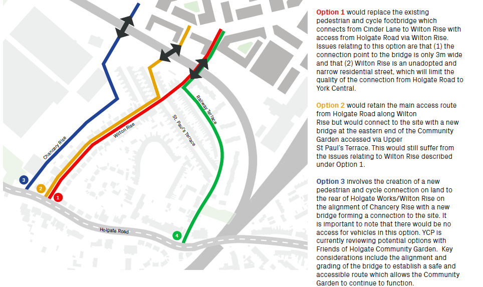
Option 3: a new path coming up Chancery Rise leading to a new bridge
This Option 3 follows the line of one the proposed routes for a new access road (the final access route chosen was the one from Water End via Millennium Green).
In principle there was an interest in the positive aspects of more people using the Holgate Community Garden and good use of any cycle path:
‘This is an “asset of community value” garden – we want people to use the garden’.
‘The more people that use any new cycle path – and the garden as well – less chance for anti-social behaviour’.
‘We want the garden to be put on the map and be better used’.
But there were some specific concerns and some specific requirements that would need to be taken into account:
Where exactly will the route go:
‘There is a massive height difference so they’d have to start ramping it very early’.
‘The worry is they will start shaving bits off the garden and play area. It’s been a long fight to protect this’.
‘There is perhaps the piece of waste land on the other side of the fence (and the basket ball court)’.
‘The bike path would not be overlooked here (to the rear of and below the Wilton Rise gardens– so it would need to be very well lit at night’.
‘We wouldn’t want to lose the trees. The trees are useful for shading and reducing noise, we’d want to keep the trees.’
Any option would need to take into account and build on the Holgate Community Gardens specialness:
‘At the moment this works well as an enclosed space where children can run around without them wandering off’.
‘The basketball court is used by groups including by the school for PE, so that would need to be kept’.
‘The residents of the area, would want ‘to get onto the cycling path at the end of the garden’ – but want the point above noted in terms of the benefits of enclosure.
Option 4 didn’t seem overly different or worthy of specific discussion as it was effectively the same as Option 1; and proceeding as if people wouldn’t use Wilton Rise if that was their shortest route didn’t seem useful.
Other options:
‘Is there another option which is further along (beyond the Holgate Works, where the business park is). The benefit would be not having to come up (the line of the railway) to go back down again.’ This had also been mentioned previously as a good link between the development and Acomb’s shops/businesses.
Notes on cycle routes:
The rejection of Option 4 was in part as a result of feelings about marked cycle routes. The streets have little vehicular traffic but a lot of parking, meaning the pragmatic safest route is often straight down the middle of the road, in order to give best sightlines for any emerging traffic and to keep clear of opening car doors. There would be little point in marking a cycle route on either side of any of the roads as it would be ignored.
Final thoughts:
• Adopting Wilton Rise: It seemed as though the recent adoption offer to Wilton Rise had been unattractive for the residents as there was an initial payment to cover assessment which would be followed by an unknown amount to bring the road up to standard before adoption. Could this offer be revisited as part of these masterplan discussions?
• Is connectivity always good? There has been an assumption that connectivity is good but there were voices of concern about great connectivity to the new community that York Central would bring. A question raised is how to recognise that communities need some kind of boundary and yet also create routes through…how do we design for both?